Friday, July 31, 2009
Thursday, July 30, 2009
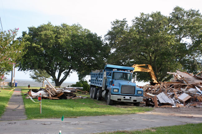
7.30- Pulling Down the House
The UMC parsonage home on South Avenue, directly across from Lou-Mac Park, is being razed, apparently due to pervasive mold infestation.-30-
The UMC is selling the lot, a prime location in Oriental's "Neuse River Heights" subdivision facing onto the river Neuse at one of the areas more popular river access points.
Monday, July 27, 2009
7.25- Tarpon Tournament
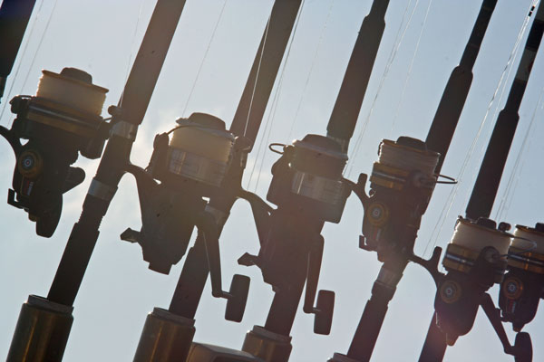
This weekend is the annual Oriental Rotary Club's "Tarpon Tournament."-30-
A "Tarpon" is a particular kind of fish that sports fishers / anglers enjoy trying to catch, at least in part due to the serious fight these rather large fish will put up.
The tournament is "catch and release," with observers on each participating boat recording the number of Tarpon reeled in to boat-side before being let loose.
Apparently Tarpon fishers often end up reeling in "skates" ... at least that is what they call them.
From what I have seen in pictures from the tourney, and the animal mounted on the "Flat Tarpon" prize that goes to whoever catches the most "skates," it looks to me like what these guys are actually reeling in are "cow-nosed rays," which swim and hunt on near the waters' surface, rather than the bottom-feeding, smaller and non-poisonous skate.
I've given up trying to correct anyone on this.
Frankly, I would rather brag about fighting for two hours to pull in a cow-nosed ray (with a poisonous barb) than a measly little bottom-feeding and totally harmless skate...
Friday, July 17, 2009
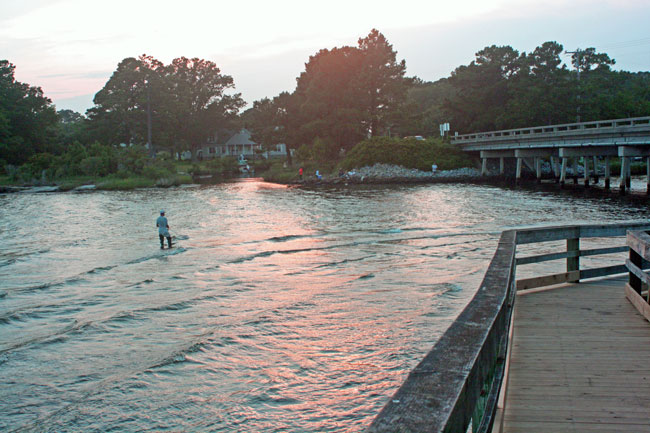
7.17- Fishing at Dawson's Creek
(Click image to enlarge)
The pier leading down to the Dawson's Creek beach under the bridge has been thoroughly repaired. (and yes, for my out-of-area visitors, this is the namesake of the TV show)
Unfortunately, it seems the creek itself is not in very great shape, as indicated by this signage posted around the popular water access site:
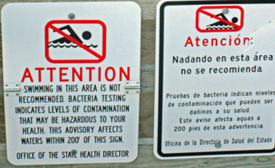
The warnings against swimming in the water did not seem to give pause to any of the dozen or so folks who were fishing around the Dawson's Creek bridge while I visited today:
-30-
Thursday, July 16, 2009
7.16 - Empty seats, full suites
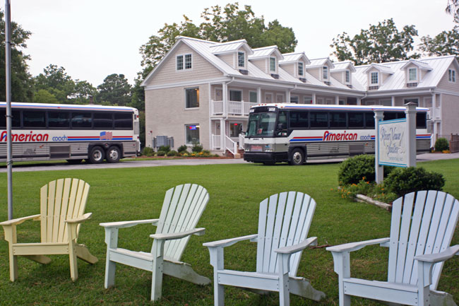
Orientals "cushy" hotel (technically a "condo-tel," but it amounts to the same thing), River Neuse Suites on the South Ave waterfront on the river Neuse, is full tonight.-30-
Under an evening drizzle, the Adirondacks on the lawn facing the Neuse were empty.
While Oriental is a visitor destination, two tour buses is still a rare sight here.
We would certainly like to see more of em as the season continues...
Wednesday, July 15, 2009
7.15- Flying fish lure
(click image to enlarge)
Today's picture comes from the fishing pier at Lou-Mac Park, Oriental NC, on the river Neuse, a few minutes before sunset.
-30-
Tuesday, July 14, 2009
7.14 - Tennessee Walker
(click image to enlarge)
Today I spotted this young man exercising one of the "Tennessee Walkers" at Chris and Debbie Fulcher's "Red Fox Stables" in nearby Merritt, NC, just outside of Oriental.
The huge stable building would dwarf many of the largest Southern Plantation Manor Homes... I'll try to get another view in a posting next week.HAPPY BASTILLE DAY to all my French friends!
-30-
Saturday, July 11, 2009
7.11-"Tanguera"
(click on image to enlarge)
-30-
ADDENDUM: I ve head from Tanguera's Captain Peter Smith with details about the boat:
“… she was designed by Joseph Hack in 1960, built in 1965 on the South shore of Long Island, owned & sailed by Hack for 30+ years and brought by him to New Bern when he retired there. Four copies were built, allowing Hack to call the 'class' after his own boat "Periwinkle". I have no knowledge of the other four. She was discussed in Woodenboat Magazine in 198..5 . She's in the Register of Wooden Boats at http://www.woodenboat.com/rwb/index.php That entry has basic descriptive info., as well.
“Between Joseph Hack & us was one owner… who looked after her very well indeed.
“Rebekah & I have had her for three years now, spending a lot of time & sweat on brightwork and topsides and other repairs & maintenance. As a wooden boat she's typically high maintenance and worth it.”
I heartily agree!
(Original post below:)
It was a perfect day for power boating, and not so great for sailing... as you can tell from the fact that there are more wrinkles in Tanguera's sails than there are on the surface of the river Neuse in today's photo.
Tanguera might as well have been at Auilis under an Artemisian curse...
As you can see on the right in today's photo, one vessel has had enough of the doldrums, and is motoring back towards Oriental.
Lucky for me I got invited onto a power boat today.
This picture was taken as some friends and I cruised around the river in a small power-boat (about 18 ft. with a 85 hp o/b), passing by all of the virtuously patient sailors drifting on the river while we checked out their becalmed boats.
Though she set no speed records today, Tanguera won today's informal prize for sharpest boat on the river... Close runner up was the +/- 50 foot Tartan sailboat (name unknown) seen in the background in today's photo on the same tack as Tanguera.
The unidentified Tartan did take the prize for "Most Likely to Be Crazy Luxurious Below and Totally Pimped," but Tanguera's classic racing-yacht lines (I'm guessing 1960's vintage design) gave her the edge for best in show... and her glowing brightwork and mirror-like hull didn't hurt either!
(Tanguera looks to me like a Pearson, perhaps Pearson Vanguard, but the sail logo does not match any Pearson logos I can find... What else could it be? If you know, please drop me a comment or an e-mail, thanks!)
Thursday, July 9, 2009
7.09- Tiki-Bar x 2
 A 60-foot sports-fisher named "Tiki Bar" out of Point Pleasant Beach, NJ stopped in Oriental NC today...
(click image to enlarge)
... And of course where else would the vessel dock but next to the 15' x 15' Tiki-Bar (background... it is surrounded by a much larger Tiki-Deck) at the Oriental Marina & Inn on Raccoon Creek, with the best view for your sunset happy/cocktail hour ?-30-
The Tiki-Bar features Oriental's finest bartenders (I have to say that or they will have my hide) as well as live music many weekends during "the Season." (call or log-on for info)
Oriental Marina and Inn hosts boat slips for cruisers, sports-fishers etc., plus hotel (well, actually "Condo-tel," but it amounts to the same thing) accommodations for overnight visitors from land or sea, showers and laundry facilities (small fee for those not docking), on-site Tiki-Bar (Best Sunset Service, Drinks and Views, as voted unanimously by yours truly) as well as the indoor bar, restaurant (and occasional live music venue) the Toucan Bar and Fresh Grill. (Just don't display any fear towards Donna... she can smell it a league away, and then you're done-for!)
For overnight accommodations ashore (comfortable full service suites) or in a convenient slip (plus Fuel Dock) at the very heart of Oriental on Raccoon Creek see Oriental Marina & InnThe Oriental Marina & Inn Monitors:
- Channel 16 (hailing) and
- Channel 71 (direct comm. with vessels coming into slips)
Tuesday, July 7, 2009
7.7- Town wins back South Avenue/"Neuse Ways" property
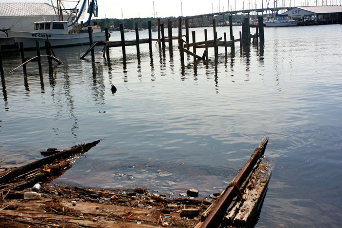 Ruins of the marine railway once operated by the "Neuse Ways Co." at the terminus of South Avenue into Raccoon Creek
 The Town of Oriental has won its claim to the "South Avenue terminus" property once used as a marine railway under terms of a lease from the town to owners of the "Neuse Ways Company" in a decision released today by the NC Court of Appeals. See the opinion at the: http://www.aoc.state.nc.us/www/public/coa/opinions/2009/pdf/080896-1.pdf-30-
The decision came on an appeal by the Town of an earlier trial court decision that granted the property to neighboring property and former Neuse Ways Co. owner Lacy Henry.
Marine railways are actual railways leading down into water (as you see in today's photo) ... they are used to pull boats out of the water using a boat cradle mounted on rail car wheels in order to perform maintenance, repair, etc. of the boats while they are out of the water.
These days marine railways have largely been replaced by modern crane-like boat-lifts...
W.G. Dixon, who was one of three founders of the Neuse Ways Company in 1923...
Tom Dixon, one of W.G.'s grandchildren and Oriental resident, told me he used to play and "help" at the business when he was a small child... he says that boats could be hauled up one by one on the railway, then they would be slid over onto the property so that up to six or eight fishing boats might be sitting on the hard at Neuse Ways at one time... and that the whole town knew when boats were being hauled out because of the noise of the steam-boiler-driven winch used to pull the boats up... the boiler was used for other machinery at the site, but the noise of boats being pulled up was unmistakable.
Following is a brief (!) history of the disputed property:
(The land comprising what is now the Town of Oriental was purchased in 1872 by town founder Robert P. Midyette... R.P. Midyette settled many family members [and perhaps former neighbors and friends from his prior residence in Dare County, NC] on his land, and soon began selling lots and parcels out of his farmland, and eventually formed the town of Oriental, which was incorporated in 1899)
Chadwick Point Sawmills and Manufacturing
The South Avenue terminus (property at issue in the case) is indicated in red on the below 1900 map of Oriental (actually a 1907 tracing of an earlier 1900 map), which map had been commissioned by the Town after the Town had "laid out" public streets in an attempt to lawfully condemn the land beneath the streets for use as public streets:
It is not clear from research conducted so far that the Town actually performed all the steps necessary to create public streets under the then-existing laws that allowed Towns to condemn public streets through a private bill passed by the state legislature... But there are other ways public streets can be legally created, in this case the process of "dedication and acceptance" where a subdivision developer's "dedication" of the property for use as a public Right of Way (ROW) is "accepted" by a governing authority (e.g. the Town of Oriental), each of which steps can be established in a number of ways under the law.
The land shown as lots 33, 32 and 31 in the above map was owned by several persons and companies that ran saw mills, grist mills and other manufacturing operations on the properties soon after R.P. Midyette purchased his 350 acres.
R.P. Midyette himself built and ran a mill complex on land within lot 31 on the above map, and possibly extending through the areas marked as South Avenue and lot 32 on the above map. (R.P.'s farmland and farmhouse complex lay along the river Neuse to the northeast of the above map area.)
The first land R.P. Midyette conveyed out of his 350 acres was the "Chadwick Point" property which he conveyed to Mr. Harrison and Mr. Morris, who erected another sawmill on the property. That property probalby consisted of the areas marked as "33" and the street marked "Smith [Pt.] on the above map.
The various mills and manufacturing sites over the next few decades (hence the name "Factory Street" leading towards the properties from the NE), though they changed ownership multiple times.
As the mills were established, R.P. Midyette also sold nearby 50 foot by 100 foot lots for use as general stores and boarding for mill workers within the areas marked as lots 32 and 30 in the above map.
Deed records from 1886 to 1898 reveal that several roads and streets already existed in the area depicted in the above map well before the town was incorporated in 1899. As just one example, what is now "Factory Street" was referred to variously as "the main road," "the road to R.P. Midyette's mill," and "the County road" in several deeds from the era.
The Oriental Bulkhead and Improvement Company:
In 1911 a parcel of land south of Lot 31 in the above map (Lot 31 belonged to the Oriental Manufacturing Company) and west of a point about where the "32" appears in the above map, was sold to the "Oriental Bulkhead and Improvement Company" (OBIC) a company formed by about a dozen town leaders and property owners who had an ingenious plan...
The OBIC was formed specifically to take advantage of the U.S. Govt. grand undertaking of constructing an Intracoastal Waterway from along the U.S. east coast. Congress had passed massive appropriations for the improvement of existing waterways along the route, as well as construction of new waterways where needed.
Part of the appropriation was for the improvement of the channel between the river Neuse and the Oriental harbor... As a condition for the dredging of the deeper channel, the Govt. required that a "local interest" find a place where the dredgings could be deposited.
OBIC was formed to become the "local interest" that would be responsible for taking on the dredge tailings... OBIC's plan was to build a bulkhead out into the mouth of Smith's Creek surrounding a 900 foot by 300 foot area of water, into which the dredgings would be pumped, forming about six acres of new land which they would then divide into lots and sell as "wharfing facilities" for commercial boats.
In 1911, OBIC purchased some former sawmill property at "Chadwick Point" (a.k.a. "Smith's Point" and now "Point Pride") facing onto Raccoon Creek, the mouth of Smith's Creek and the river Neuse.
The deed transferring the property purported to include the area shown as "South Avenue" west of "Wall Street" in the 1900 map above (though there is plenty of other deed evidence that there were .
The Pamlico County Register of Deeds office has the following plat of the OBIC scheme in its plat cabinets (I have colored the South Avenue terminus property in red) :The OBIC plat bears no date, and the Register of Deeds has no record of when it was filed, but the irregular shape of the peninsula on the plat leads me to believe believe it was filed after the following events:
OBIC built the bulkhead, and the U.S. Govt. hired a New Jersey company to dredge the channel and to deposit the dredgings into the OBIC bulkhead.
Unfortunately for OBIC, the bulkhead failed in numerous places during the dredging and filling process, causing some of the dredgings to simply spill back into the surrounding waters, and seriously compromising the remaining bulkhead structure and the remaining filled land within it.
OBIC sued the New Jersey company, claiming the dredge captain had negligently attached some of his equipment to the bulkhead and that he had negligently failed to spread the dredgings evenly within the bulkhead as he filled it, which actions caused the bulkhead to fail in several places... The New Jersey company defended itself by asserting that OBIC had built a faulty bulkhead, claiming that the U.S. Govt. engineers had declared the bulkhead insufficient for the project.
OBIC eventually won the lawsuit, and was awarded $5,000 in damages... but it was too little too late to revive the project. OBIC abandoned the development scheme and went into receivership.
Benjamin Wallace O'Neal:
The Bank of Oriental, which held the mortgage on the OBIC land, foreclosed on the property, and in 1917 sold the land at auction to winning bidder Benjamin Wallace O'Neal, who had been one of the directors of OBIC.
In late 1917 and early 1918, B.W. O'Neal sold off 31 of the 34 lots shown on the OBIC plat (I have found no records for three of the lots)... the deed for each of the parcels O'Neal sold all refer to lot numbers on the OBIC plat...
The deed for Lot #1 (click on image at right for full deed... see Lot #1 immediately below the "H" of "South Avenue" on the OBIC plat, above) additionally described that lot as "facing onto South Avenue..." though none of the deeds for the other 32 lots mention streets, relying instead on the lot numbers in the OBIC plat for property descriptions:Detail of first deed for OBIC Lot No. 1
The Neuse Ways Company:
In early 1923, Lot #4 on the OBIC plat (immediately below the red-colored South Avenue terminus in the OBIC plat above) was purchased by Mr. W.G. Dixon, Mr. Seth Sanders, and Mr. Senae D. Zeh. The deed described the property simply as "Lot # 4 in a subdivision of the Oriental Bulkhead and improvement Property."
By 1928 W.G. Dixon had purchased Mr. Sanders' and Mr. Zeh's interests, giving Dixon sole ownership of OBIC Lot #4.
According to a 1951 deed (discussed further below), the Dixon and his partners immediately established a "marine railway" and boat repair business called "Neuse Ways Company" on the property when they acquired it in 1923.
At least as early as the late 1930's, W.G. Dixon began leasing (from the Town of Oriental) the South Avenue terminus property that was adjacent to the "Neuse Ways Co." lot (OBIC Lot #4) in order to use the additional land for the marine railway and boat repair business.
In the days of marine railways, the Town apparently felt that having a viable boat repair facility available for the commercial fishing fleets operating out of the area was important enough that the town was willing to lease the street end to the Neuse Ways Co. for token amounts ($1 to $15 per year on ten-year leases.)
The South Avenue terminus had never been needed to access adjoining properties (which also front other parts of South Ave. or on other streets), so the Town agreed to let the adjoining property owner, W.G. Dixon lease the terminus in order to expand his marine railway business on Raccoon Creek.
Dixon may well have been leasing the South Avenue terminus property from the Town of Oriental since 1923... Unfortunately the Town's records for that period are missing or have been destroyed.
By 1938, the Town of Oriental had commissioned a new survey of the town, resulting in the following map (the "South Avenue terminus" area is again highlighted in red below... also note how much the OBIC peninsula had eroded by then):
In 1951, W.G. Dixon sold his marine railway business and OBIC Lot #4 to Lacy C. Henry and Curtis Benton. (click on image at left for 1951 deed... again the real property is described only as OBIC Lot#4)
According to Town records, the Town's Board of Commissioners at the time agreed to transfer Dixon's remaining lease interest to Henry and Benton, who continued to run the "Neuse Ways" marine railway on the property. This is reflected in the 1951 deed to Henry and Benton, which specifically provided:
Town records show that Lacy C. Henry continued to renew leases of the South Avenue terminus until he transferred the OBIC Lot #4 to his son, Lacy M. Henry, in 1977.Lacy M. Henry's First Land-Grab - Neighboring Fulcher property:
Unlike ALL previous deeds for the property, the 1977 deed from father Henry to son Henry did not describe the property solely as "OBIC Lot #4... This is the first deed in the chain that includes "metes and bounds" descriptions of some of the property lines for the lot.
(click on image at right to see the deed)
Though it included the new "metes and bounds" language describing the property, the 1977 deed nonetheless continued to recognize the southern edge of South Avenue as being the northern border of the property:
Lacy M. Henry quickly landed in a property line dispute with Oriental Fishing Baron Garland B. Fulcher, who owned the land immediately south and west of Henry's OBIC Lot # 4... It was a heated dispute, involving parking vehicles and moving equipment to block neighbor's respective use of the disputed border area, and Fulcher and Henry each sued the other over the matter...
Apparently, the purpose of the "metes and bounds" description in the 1977 deed from father Henry to son Henry was to claim ownership of land in the SW corner of Lot #4 that bordered on OBIC Lot #8, owned by Garland Fulcher.
In court, Henry claimed that the disputed corner between the two properties (SW corner of Lot # 4 and NE corner of Lot #8) was his based on the following theory: The original OBIC Plat filed in the County Register of Deeds Office was ambiguous , and Henry had acquired a "Deed of Correction" describing the disputed corner as being within Lot #4... Indeed no border line between Lot # 4 and the adjacent Lot #8 is visible on the OBIC plat that is on file in the Pamlico County Register of Deeds Office:
Henry acquired the "Deed of Correction" from a Ms. Ann Wadley Wing, who had been named as the executrix and the residuary beneficiary of the late Benjamin Wallace O'Neal's will. The "Deed of Correction" included the same metes and bounds description father Henry had included in his deed transferring the lot to son Henry.
Apparently Henry felt that the original subdivider of the OBIC property (OBIC or O'Neal) or the subdivider's surviving heirs or assigns (in this case Ms. Ann Wadley Wing) had the authority to correct any mistakes in the original subdivision property descriptions.
During the course of the lawsuit, Fulcher and Henry reached an agreed settlement, and the Court issued a Judgment that described each of the properties according to the Fulcher-Henry agreement... It essentially gave each of them 1/2 of the property Henry had claimed to have gained by virtue of the Ann Wadley Wing "Deed of Correction."
The agreed Judgment set forth new, detailed "metes and bounds" descriptions of both the Fulcher and Henry properties, but Henry's property was still described as running along the southern border of South Avenue:
Lacy M. Henry's non-Land-Grab" of "Front Street"
Lacy M. Henry also acquired documents from Ann Wadley Wing purporting to grant him ownership of a portion of "Neuse Front Street" (a.k.a. "Front Street") east of "Avenue A" as depicted on the OBIC plat) where it bordered another nearby property he purchased...
The street had long fallen into complete non-use...
In fact some fifty years before Henry acquired the "Front Street" documents from Wing, the owner of a neighboring property had lost a lawsuit attempting to force the Town of Oriental to repair the street and the bulkhead protecting the street from the encroaching waters of the Neuse River... The Town successfully defended itself in the suit by establishing that Front Street was a private street which had never become a public street through the legal "dedication and acceptance" method of creating public streets... Notice also that "Front Street" does not appear on the original 1900 / 1907 Town Map...
(Also, as you read on below, keep in mind that whether it was a private street or not, the portion of "Neuse Front Street" lying east of "Avenue A," WAS NEVER WITHIN THE OBIC SUBDIVISION... though it does appear on the OBIC subdivision map, it was not within the borders of land owned by OBIC or B.W. O'Neal)
(I am not going into further detail about "Neuse Front Street" here at this time because the issue appears moot, except inasmuch as it shows a continuing modus operandi of Lacy Henry using Ann Wadley Wing documents to attempt to add to his existing properties... I am also not addressing the histories of "Main Street" or "Avenue B" as depicted in the OBIC plat, both of which were created by the OBIC/O'Neal subdivision)
Lacy M. Henry's Second Land Grab - neighboring South Avenue Terminus:
When the last Lacy M. Henry/Neuse Ways Co. lease of the South Avenue terminus expired in the early 1990's, marine railways had become anachronistic and the Neuse Ways business had come to an end. Lacy M. Henry then asked the Town to sell him the South Avenue property so he could add it to his existing (and very small) OBIC Lot #4. The Town declined to sell the land to Henry.
Having failed to purchase the land, Henry came up with what can only be called a sneaky scheme to claim the land as his own...
In March of 1995 Henry acquired a "quitclaim deed" from Ann Wadley Wing as the residuary beneficiary of Benjamin W. O'Neal.
The quitclaim deed essentially claimed that the roads on the OBIC plat had never been dedicated for use as public roads, and the Town of Oriental had never accepted the plat's streets as public roads... the QC deed went on to assert that because they had never been legally dedicated to public use, Ms. Wing therefore inherited the land making up the streets because she was the residuary beneficiary of Mr. B.W. O'Neal's will... as such, she was transferring her ownership of the land making up the South Avenue terminus to Lacy M. Henry.
About one month after she purported to have transferred any ownership interest she may have had in the South Avenue terminus property to Lacy M. Henry, Ms. Wing filed a "Declaration of Withdrawal" purporting to withdraw any dedication of the streets on the OBIC plat to the public's use (while at the same time claiming they had never been dedicated in the first place.)
Lacy M. Henry then erected a chain link fence around the South Avenue terminus property adjacent to his own OBIC Lot #4.
The Town government seems to have either not known what to do about this situation, or to have not cared enough to do anything more than write letters to Henry objecting to his fence, then writing Henry to say the Town would allow the fence to stay up in order to protect the Town from liability arising from someone being hurt by walking around the terminus property, which was strewn with equipment and machinery.
When the Town learned that Lacy M. Henry had applied to the State of NC for permission to build an eight-slip private marina along the waterfront on his OBIC Lot #4 AND on the South Avenue terminus (Mr. Henry's CAMA application included maps indicating South Avenue waterfront on Raccoon Creek belonged to him), the Town had its attorney intervene in the CAMA application process and filed a lawsuit against Mr. Henry to establish Town control over the South Avenue terminus he had fenced off.
Years passed as neither party pushed resolution of the lawsuit (Henry was in bankruptcy for some of that time). Both sides in the dispute eventually filed Motions for Summary Judgment asking the court to decide the issue before holding a trial, based only on the claims and evidence already filed with the court.
The case was finally heard on New Years Eve, 2007, by Judge Crow at the trial court level in Bayboro. Judge Crow subsequently issued an opinion granting Henry's Motion for Summary Judgment... It is fairly clear that the opinion was actually drafted by Henry's attorney, and was not really based in reality of facts or laws applicable to public streets.
The Town appealed the decision to the NC Court of Appeals, which today released its decision reversing the trial judge and finding that the South Avenue terminus is a public street that was dedicated to and accepted by the Town, and therefore Henry loses.
So What Does it All Mean?
While we do have to wait and see if Henry appeals to the Supreme Court, today's decision means that the Town has the right to control the portion of South Avenue leading down to Raccoon Creek / Oriental Harbor.
OK, so how useful is that? Why is it so important to have the street go all the way to the water if nobody needs the street to get to and from their property?
I have two primary answers:
#1 - Allowing Henry to get away with adding a public street to his own real property would set a dangerous precedent, tempting Henry himself, as well as other property owners, to simply fence in public rights of way and waiting for the Town to cave in... This would be especially dangerous in the case of Lacy Henry because he owns several properties that are depicted on the OBIC plat but which were never part of the OBIC subdivision...
Henry's "non-grab" of "Front Street" via the use of Ann Wadley Wing "withdrawal of dedication" and "quit-claim" deeds (as well as language in the Ann Wadley Wing documents I have not described here) strongly suggests that as far as Henry is concerned, Ann Wadley Wing has the right to dispose of ALL STREETS APPEARING ANYWHERE IN THE OBIC PLAT, WHETHER THEY WERE PART OF THE OBIC SUBDIVISION OR NOT! Under this theory, Henry or anyone else could purchase or acquire from Ms. Wing any or all of the land under any of the streets depicted on the OBIC plat.
This would presumably include South Avenue from Raccoon Creek all the way to a point NE of the intersection of South Avenue and Wall Street, as well as the intersection of Wall Street and South Avenue (a heavily travelled intersection in Oriental) and Wall Street from the Neuse River to a point NW of the Wall & South intersection.
Other property owners around town might also track down descendants of whoever originally subdivided their neighborhood and use Henry's tactics to attempt to claim ownership of ANY OTHER STREET PROPERTY IN THE TOWN.
Yes, this lawsuit has cost the town a good chunk of change, but how much more would a wider attack on public streets cost in the future?
#2 - It seems that old (but still applicable) common-law doctrines of "Riparian Rights" and public Rights of Way recognize that when a developer creates streets within a subdivision which dead-end at public waterways, it is presumed that the dedicator intended for the public to have access to the waterway from the street end...
That means the public may build docks, boat ramps, etc. in order to use the water access granted by the dedicator.
Currently, the Town maintains a public dock extending off of the Hodges Street causeway across Raccoon Creek, which can accommodate two or three boats at a time... new docks could mean space for another four or more boats full of visitors coming into Oriental to spend money!
Of course, the property is currently overgrown and littered with old machinery, trash and the ruins of the railway and two docks jutting into the water... Cleaning up and building new docks will take time and money, but hopefully the Town can find funding from State and Federal sources to build such valuable water access facilities for public use.
Saturday, July 4, 2009
7.4 - Happy 233rd!
(click on image for full size)
The town of Oriental's annual Croaker Fest is always the first Saturday in July... this year that happened to fall on Independence Day, so multiple fireworks shows were visible from atop the Hwy. 55 bridge tonight... I counted five displays going on at once along the horizon.
The above photo was taken from near the top of the Hwy 55 bridge over Smith's Creek, looking west up Green's Creek... the fireworks were shot off from Dewey Point, the purported favorite vacation spot of Blackbeard the Pirate, and one of many places he is supposed to have buried treasure.
The photo below was taken from the bridge, but looking in a Southeasterly direction... Plenty of boats anchored in Oriental harbor and in the river Neuse near the harbor entrance... Notice the TWO FIREWORKS DISPLAYS ON THE HORIZON (one near center, the other on the right side):
If you can't be on a boat in the creek or harbor, the bridge is the best vantage point for the fireworks... it is closed off to traffic during the display:
When the fireworks ended, boats started weighing anchor and clearing out of Green's Creek:
-30-
Friday, July 3, 2009
7.3 - Searching for the rudder
Thursday, July 2, 2009
7.02- SkyWatch Friday - Clouds over the OYC
(Click image to enlarge)
The common pattern of heat-fed afternoon thunderstorms set in this last month, and we can expect to see plenty more dark clouds forming suddenly around us, followed by heavy bursts of rain and cloud to ground lightning.
Today's picture was taken at the Oriental Yacht Club on Raccoon Creek and Oriental Harbor a few days ago.
I look forward to seeing the other Skywatch pictures from around the world on the other SWF sites listed at:-30-
Wednesday, July 1, 2009
7.01- The hump in the harbor
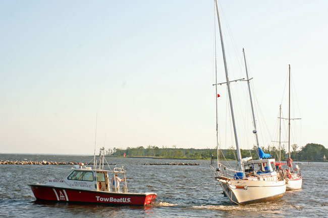
The "hump" in the Oriental harbor anchorage earns TowBoat U.S. a good bit of business!
The hump is located behind the sailboats docked at the Oriental Yacht Club... If you are coming into the harbor to anchor, look for the funky old covered deck (with big "OYC" in blue facing SEy)... DONT GO ANYWHERE NEAR THE AREA BEHIND THE BOATS AT OYC UNLESS YOU HAVE FEWER THAN FOUR FEET OF DRAFT! I'd say be careful with anything over THREE feet of draft, actually.
SEE THE AREA IN YELLOW BELOW:NOT MEANT FOR NAVIGATIONAL PURPOSES:
-30-
Subscribe to:
Posts (Atom)


