A photo a day from Oriental, NC, the surrounding Pamlico County area, and nearby rivers, creeks, bays and other waterways of coastal North Carolina.


Oriental Daily Photo is a member of the City Daily Photo blog network.
See daily photos of other towns and cities around the world at:
CDPB Logo

Tuesday, March 31, 2009

3.31- Victorian Gingerbread

Gingerbread gable at 400 Mildred St., Oriental

Victorian gingerbread adorns the roof eave of this home at 400 Mildred St., Oriental.

So far as I can tell, this home was built in a neighborhood that was subdivided and developed after the death of Queen Victoria... The home is in the Neuse River Heights subdivision, which was platted out in 1906 (SEE PLAT, BELOW)

But the gingerbreading hints at pre-1900 design, if not construction.

Please, if anyone knows anything about the history of this home, at the corner of Mildred St. and Second Ave., please drop a comment or send me an e-mail!

Here is a portion of the 1906 Neuse River Heights Plat... the location of the above house is marked in red... notice that the plat includes existing dwellings on a number of lots, but not on the lots where the above home is located:
(Click on image for full size)


-30-

Friday, March 27, 2009

3.27- Pagoda and dredge

Yard pagoda on the bank of the River Neuse

A dredging barge enters Whittaker Creek channel near this miniature pagoda adorning a yard along the River Neuse. Dragons are the usual symbol of Oriental, but this pagoda seems fitting as well.

The backhoe on the barge is used to scoop out mud/earth in channels, along docks, etc. to allow boats to enter without running aground. The two tall stick-like objects on the barge are lowered into the river/creek bottom to hold the barge in place while the backhoe does its job. This dredge is not dredging in the photo, but is merely in transit, puttering along into Whittaker creek from the River Neuse.
-30-

Thursday, March 26, 2009

3.26- Barn without walls

A farm building offers shelter against the misting rain


I passed this barn-like structure on Bay City Rd. (NC 1002), somewhere near the border of Pamlico County and Beaufort County (just to the north of Pamlico Co.).

I wonder if the building is meant to not have walls, or if the walls have fallen down?

A misty/rainy day here in Down-East NC... hopefully we can look forward to a verdant Spring and Summer.


-30-

Monday, March 23, 2009

3.23- Skateboard kids

Skateboarders on Midyette St.
Some young skateboarders were cruising down Midyette St. towards the Wildlife Ramp as the sun sank in the evening sky.

The Midyette family founded Oriental... In 1872, Robert P. Midyette purchased 350 acres of land which would eventually become the town of Oriental. At the time, the land was timberland and farmland.

Several members of the Midyette family came with Robert to settle on the land, and several of the early Midyette homes were built between Camp Creek and what is now Midyette St... Including, I believe, the houses in the background above.

In the late 1880's, Robert P. Midyette began subdividing and selling lots near Chadwick Point (the confluence of Raccoon Creek and the Neuse River), southeast of Midyette St.

The earliest parcels were developed into a lumber mill and mill worker tenaments (owned by lumber mill owners), a store, and warehouse and docking facilities on the Neuse River for the Old Dominion Steamship Company.

As more residential and commercial lots were subdivided, the town of Oriental was chartered (March 4, 1899), and the bustling little fishing and lumbering village grew, the Midyette descendants continued living on a 100 acre (more or less) plot along Midyette St. that remained un-divided until well after R.P. Midyette's death in 1902.

The Midyette family compound (which soon included homes of families by marriage) stretched along the banks of Camp Creek and Midyette St. to the town's gate at what is now the intersection of Midyette St. and North St.

(Yes, Oriental was originally a "gated community"... One early town ordinance imposed a 5$ fine for anyone who left the town gate open at night, presumably because there were free-roaming farm animals within the town borders.)
-30-

Sunday, March 22, 2009

3.22- "Local Knowledge" aids to navigation

Whittaker Creek Range Markers (dayboards)

Range markers are very helpful aids to marine navigation.

These markers are on the shore of Whittaker Creek... Boaters traveling the channel between Whittaker Creek and the Neuse River can use these markers to stay within the channel that has been dredged out of the surrounding shoal.

A boater headed into Whittaker Creek from the Neuse River can maneuver the boat so that the orange stripes on these two markers appear lined up... the rear marker is higher than the forward marker, allowing a boater to see both markers when they are lined up (or when they are not).

When headed out of Whittaker Creek into the Neuse, the boater must occasionally (actually, frequently is more advised) glance behind to make sure the markers are lined up.

The picture below was taken from directly in front of the forward/lower marker while looking straight down Whittaker Creek channel into the Neuse River - A boater coming into the creek would maneuver the boat to keep the markers on shore lined up (as conceptually depicted below), making sure that the boat is staying in the middle of the channel:


I have seen many a boat go aground navigating this channel... apparently staying within the channel markers (the posts sticking out of the water in the aboe photo) is not all that easy, and in any case may not guarantee a deep enough passage, depending on the boat, so the on-shore range markers are a great help.

I believe this particular range is a "private" range constructed by locals and not the Coast Guard... therefore they probably don't show up on charts, and constitute a bit of "local knowledge."

Here are the approximate locations of the Whittaker Creek channel and Range Markers (dayboards):


-30-

Thursday, March 19, 2009

3.19- "Thirsty Thursday" at The Silos

The Silos Restaurant & Saloon at twilight


The Silos is located on NC Hwy. 55 just a couple hundred yards outside the Oriental town limits.

It always draws a large crowd on Thursdays for $1.00 pint draft beer specials... including Yeungling, my preference.

Complementary peanuts are a signature of the place, though the new owners/management (who came in last year) introduced the revolutionary concept of sweeping up the peanut shells off the floor every few days or so... prior owners did not, and peanut shells formed dunes and drifts wherever people did not walk... Some customers, including myself, favor the old leave-em-on-the-floor approach.

From what I understand, these were actual silos on the property, converted into a bar/restaurant by the previous owners... Currently, only the left-hand silo is open for business.


-30-

Wednesday, March 18, 2009

3.18- Pear trees


Pear tree in bloom

Pear trees are blooming all over the area lately.

Today the sun has come out (after several grey rainy days), making them more brilliant.

This tree is in front of the Oriental Freewill Baptist Church on Ragan Rd... The Church's message board today reads:


-30-

Monday, March 16, 2009

3.16- Spring Chickens

Chickens prove the truth of the "Vari Kennel" name for their temporary roost

This small flock of chickens was spotted in Oriental's old village as they awaited trans-shipment through town... their ultimate destination is a farm in the mountains of western NC.

The four hens and a cock are not destined for dinner-plates, but for egg-laying and pecking around the farmyard.


See a couple additional chicken-pics on today's Dinghy Dock.


-30-

Thursday, March 12, 2009

3.12- Skywatch Friday - Sunrise over Chadwick Point


The sun rising over Chadwick Point (home of Point Pride Seafood)

Today's picture is from a boating trip earlier this week... a neighbor and I joined mutual neighbor Capt. Miller on his May Craft 1900 for a trip across the River Neuse, into Turnagain Bay, and through the "Indian Ditch" connecting Turnagain with Long Bay. (see prior post, below)

We left from the Wildlife Ramp on Smiths Creek and were crossing the mouth of Smiths Creek / Oriental Harbor just as the sun peeked over the point. An itinerant catamaran was at anchor in the harbor.

The rising sun illuminated the web of contrails left in the dry atmosphere by the many high-altitude commercial airplanes moving up and down the East Coast flight corridors.

HAPPY SWF EVERYONE!

I look forward to seeing the other Skywatch pictures from around the world on the other SWF sites listed at:

-30-

Wednesday, March 11, 2009

3.10- Springtime on "Indian Ditch"

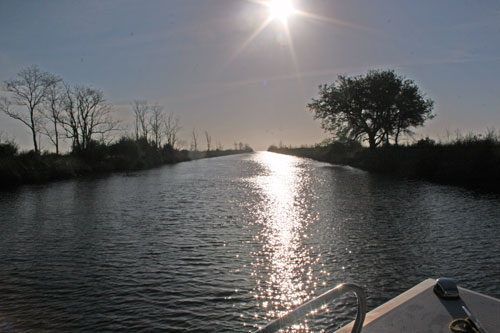
Budding tree overlooking marshland on the southern side of the "Indian Ditch" between Turnagain Bay and Long Bay
(Click on image for full size)

Spring continues to evince itself along the waterways of Down East NC... This shot was taken on the banks of a canal known to locals as "Indian Ditch."

This particular "Indian Ditch" runs about 1.25 miles through marshland between the heads of Turnagain Bay on the West and Long Bay on the East, a convenient shortcut to the other side of Piney Island (home of the U.S. military's "BT-11" target range... as signs along the north bank of the ditch attest [see picture at right])

The term "Indian Ditch," as far as I can tell, refers to irrigation and transportation canals built by Native Americans... I have found no authoritative information on the history of this particular ditch, but have found U.S. Govt. references to the "Indian Ditch" as comprising the southern border of the "BT-11" target range.


Native people did dig irrigation and communication ditches through marshlands in what is now NC... The Waterman’s Song – Slavery and Freedom in Maritime North Carolina, David S. Cecelski, (2001, UNC Press, Chapel Hill), the author describes how African slaves were the primary inheritors of Native knowledge of local fisheries, waterways and techniques, and that English colonists and African slaves also inherited Native fishing and water infrastructure, including canals:
“Beginning with an English assault on the Chowaneoic in 1679 and ending with the Tuscarora War three decades later, colonists and their slaves also took over the maritime infrastructure created by the coastal Indians. They adopted marsh canals excavated by Coree boatmen, confiscated trails worn down by Tuscarora autumnal migrations to the fishing beaches, pulled their seines by former Chowaneoic fish camps, placed fish impoundments where Moratuck weirs had stood..."
(Cecelski, at p. 20)

If the ditch was indeed originally built by Native Americans, I have a feeling it has since been improved by the U.S. Army Corps of Engineers, seeing as how it is a good 5 feet deep and 80 feet wide for its entire 1.25 mile straight-line run through swampy marshland.

Trees grow along the ditch where the canal's dredgings have been deposited, forming dry land berms/dikes between the canal and the surrounding marshlands.

It is hard to imagine such an engineering feat using hand tools and stone-age technology, though I would readily believe that Native Americans built some sort of waterway communicating between these two bays to provide for canoes or other small fishing boats.

It would certainly make sense for area natives to want a shortcut from the Neuse River estuary to fisheries of Long Bay and West Bay, and, via another purported "Indian Ditch," all the way to the waterways now known as Core Sound.

Please, if you have any info on the history of this ditch, or know of some sources I could consult, please drop me a comment or e-mail.

Here is a shot of the ditch, followed by a Google map showing its location:


View Larger Map

[Steven has left a comment on The Dinghy Dock, linking to an 1884 U.S. Coast Survey map on the University of North Carolina "NC Maps" site which shows an "Old Canal" at the location of today's photographs:


Thanks for the reference, Steven!... UNC's NC Maps on-line collection is news to me, and I am enjoying looking through all the maps... So far I have found an 1844 postal map showing a waterway passing between the Neuse River and Long Bay, again in the same place as the above "Indian Ditch.":


-30-

Monday, March 9, 2009

3.09- Kershaw Creek

Capt. Miller at the helm, cruising up Kershaw Creek
(Click on image for full size)

The weather is finally turning to Spring... a beautiful 85 F, sunny day here in the ONC.

Today I had the pleasure of joining Capt. Miller for a pre-season "shake-down cruise" on his May Craft 1900, just to make sure the engine wintered OK... After a little work cranking the engine, everything went smoothly.

I look forward to some more power-cruises with Capt. Miller as the season advances... I might even have to break down and get me a fishing license!
-30-

3.08- The Happy Couple

Mr. Mark Blango and his bride, Ms. Andrea (Jones) Blango are all smiles on their wedding night
(Click on images for full size)

Mr. and Ms. Blango were married yesterday at the Deliverance Temple in Bayboro, and were out and about at my local tavern with some of the wedding party in the wee hours this morning:


Ms. Andrea (Jones) Blango hails from Stonewall, while the happy groom is from Aurora... both towns are right nearby here both in Pamlico County, NC.

Ms. Blango is a sailor in the U.S. Navy and works managing haz-mats, while Mr. Blango pursues his apprenticeship as an electrical lineman in the private sector (on-shore.)

They will be off to Vegas for their honeymoon come Monday.

Congratulations!

-30-

Sunday, March 1, 2009

3.01- Ben's Chili Bowl - the line

Cooking the "Half-Smokes" at Ben's Chili Bowl on 14th St., NW, Washington, DC


More road-trip today... last day in DC for this visit, so a trip to Ben's Chili Bowl was in order... Yes, do the half-smoke with the chili, onions and mustard. The mustard is critical, if you ask me.


-30-